
A residential development layout is a detailed, scaled plan showing how dwellings, roads, parking, and open spaces are arranged within a development site. Known formally as a block plan or site layout plan, it operates at scales of 1:500 or 1:1000 and forms a mandatory part of any UK planning application. For developers, investors, and architects working across London, West London, and Hertfordshire, this document is not optional paperwork. It is the technical foundation on which planning permission, construction coordination, and regulatory compliance all depend.
What is a residential development layout?
A residential development layout is a precise, scaled drawing that maps every key element of a proposed housing scheme within the site boundary. It shows building footprints, access roads, pedestrian routes, parking provision, landscaping, and utility corridors in a single coordinated document. Local planning authorities in England require this drawing to assess whether a scheme respects its surroundings, meets highway standards, and delivers adequate amenity space.

The layout differs from a sketch or concept drawing. Residential site plans are precise scaled drawings used for planning and permit approval, not informal illustrations. That precision matters because councils measure setbacks, parking counts, and distances to boundaries directly from the submitted drawing.
Developers who treat the layout as an afterthought consistently face delays. Submitting an inaccurate or incomplete layout is one of the most common reasons planning applications are invalidated before they even reach a case officer.
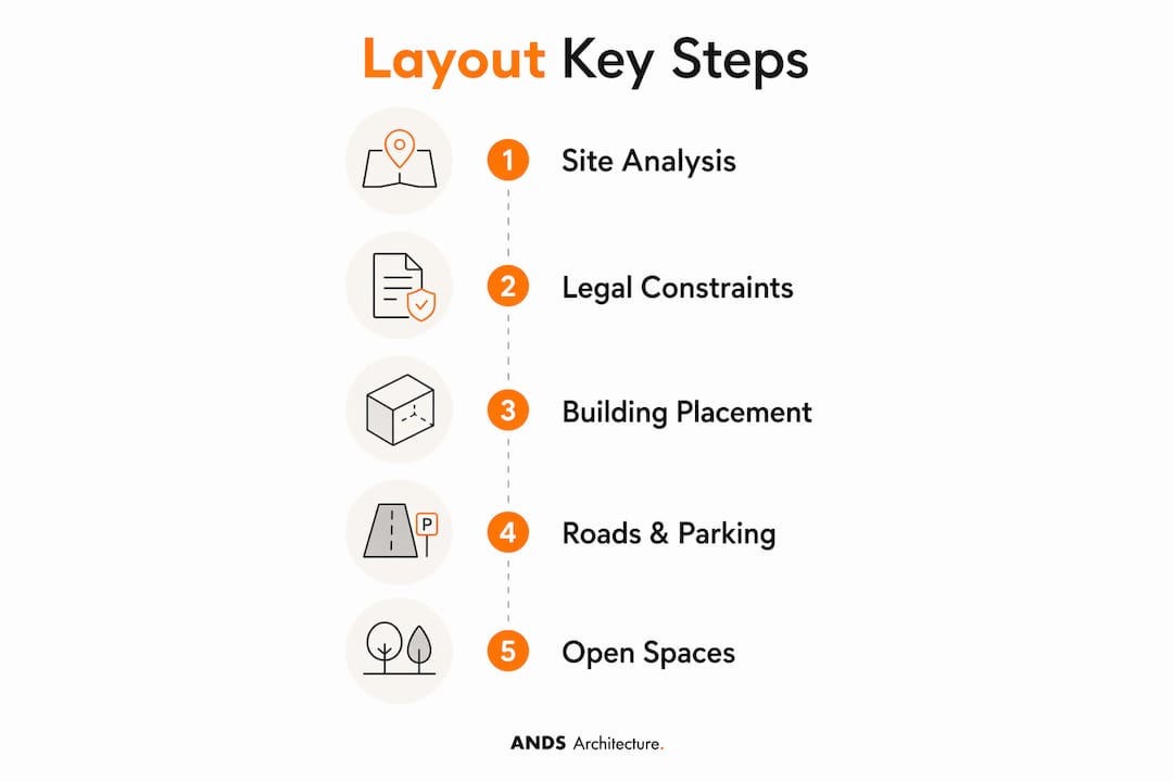
What key elements comprise a residential development layout?
A well-prepared site layout plan contains several distinct layers of information, each serving a different audience within the planning and construction process.
- Building footprints and orientation: The plan shows the exact position, size, and orientation of each dwelling. North points and shadow studies may accompany the layout to demonstrate daylight and overshadowing impacts.
- Internal roads and pedestrian routes: Access roads, shared surfaces, footpaths, and cycle routes are drawn to scale. Highway engineers use these dimensions to confirm compliance with Manual for Streets standards.
- Parking provision: The layout must show every parking space, including disabled bays, turning areas, and visitor parking. Many London boroughs and Hertfordshire councils specify minimum ratios per dwelling type.
- Landscaping and open space: Play areas, communal gardens, tree positions, and boundary treatments appear on the layout. These elements directly affect the planning officer's assessment of amenity and biodiversity net gain.
- Utility corridors: Drainage runs, electricity substations, gas mains, and telecoms ducts are indicated to prevent clashes during construction.
- Site boundaries, setbacks, and easements: The plan marks the red line boundary, building lines, and any legal constraints that restrict where structures can be placed.
- Construction phasing: Larger schemes show phasing overlays so that infrastructure can be delivered in sequence without disrupting occupied plots.
Pro Tip: Always include a phasing plan on schemes of ten or more units. Planning conditions frequently require phased delivery of open space and infrastructure, and a layout that already shows this logic speeds up the discharge of conditions considerably.
The layout also functions as an information package for trades, directing roads contractors, drainage engineers, and landscapers rather than serving purely as an architectural drawing. That multi-disciplinary role is what makes accuracy so consequential.
How does a residential layout differ from a site location plan?
Developers regularly confuse three distinct plan types: the site location plan, the block plan (site layout), and the floor plan. Each answers a different question, and councils require both the location plan and the block plan for every planning application.
| Plan Type | Scale | Primary Question Answered | Key Content |
|---|---|---|---|
| Site Location Plan | 1:1250 or 1:2500 | Where is the site? | Site position within the neighbourhood, roads, and surrounding buildings |
| Block Plan / Site Layout | 1:500 | What is changing on the site? | Building positions, boundaries, parking, landscaping, distances to neighbours |
| Floor Plan | 1:50 or 1:100 | What is inside the building? | Room layout, internal dimensions, door and window positions |
The site location plan provides neighbourhood context. The block plan at 1:500 provides the fine-grained detail that planning officers use to measure setbacks and assess neighbour impact. Floor plans, by contrast, show internal arrangement and play no role in site layout assessment.
Confusing these plan types causes real problems. Submitting a floor plan where a block plan is required, or using the wrong scale, results in an invalid application and a wasted validation fee. The red line on the location plan must match the site boundary shown on the block plan exactly. Any discrepancy triggers a request for amended drawings before the application clock even starts.
What design principles guide effective residential site layouts?
Creating a layout that wins planning approval and works on site requires more than placing buildings on a drawing. The following principles reflect best practice for UK residential schemes.
-
Maximise the developable area within constraints. Setbacks, easements, and highway visibility splays reduce the buildable envelope. Map these constraints first, then design within them. Attempting to design without this information leads to rework.
-
Prioritise access and circulation from the outset. Highway access is frequently the most technically constrained element of a residential layout. Engage a highway consultant early. A turning head that does not meet the local authority's adopted standards will require redesign regardless of how well the rest of the scheme is resolved.
-
Meet parking standards for the specific borough or district. Parking ratios vary significantly across London boroughs and Hertfordshire districts. Ealing, Harrow, and Watford each publish their own standards. Designing to a generic ratio and then adjusting late in the process wastes time.
-
Integrate landscaping as a design element, not an afterthought. Biodiversity net gain is now a legal requirement under the Environment Act 2021 for most new residential developments in England. Tree positions, hedgerow retention, and SuDS drainage features must be shown on the layout from the first draft.
-
Coordinate utilities and drainage before fixing building positions. GIS data, parcel maps, and site visits are used to integrate utility information into the layout. A building positioned over an existing sewer requires a build-over agreement or a diversion, both of which add cost and time.
-
Design for phased delivery on larger schemes. Show which roads, drainage connections, and open spaces are delivered in each phase. This prevents later phases from being landlocked or lacking services.
-
Use accurate scales throughout. Submitting a drawing that is not to scale is a common validation failure. Every dimension on the layout must be measurable and consistent with the stated scale bar.
Pro Tip: Run a constraint plan as a separate drawing before starting the layout proper. Show all setbacks, easements, overhead lines, and tree root protection zones on a single base drawing. Every design decision then references this constraint map, and nothing gets missed.
What are the roles of 2d and 3d visualisations in layout planning?
Residential layouts are produced in two distinct formats, and each serves a different purpose within the planning and development process.
2D layouts are overhead, scaled drawings used for measurement, documentation, and statutory submission. They are the format required by planning authorities and building control. Every dimension, setback, and parking space count is read from the 2D drawing. No planning application in England can be validated without one.
3D layouts serve a different function entirely. They illustrate realistic materials, landscaping, and massing to support stakeholder communication and client presentations. Key uses include:
- Client and investor presentations: A 3D aerial view communicates the character of a scheme far more effectively than a 2D plan to non-technical audiences.
- Design team coordination: 3D models help identify clashes between building volumes, roof forms, and landscape features before construction begins.
- Marketing and pre-sales: Developers use 3D visualisations to market units off-plan, often before planning permission is granted.
- Planning committee presentations: For schemes that go to committee, a 3D visualisation can be decisive in helping elected members understand the proposal.
Software commonly used to produce these outputs includes AutoCAD and Revit for 2D technical drawings, and SketchUp, Lumion, and Enscape for 3D visualisation. The 2D drawing remains the legal document. The 3D model supports understanding and communication.
How do setbacks, easements, and site constraints shape your layout?
Setbacks and easements are the territorial constraints that define the buildable envelope within any residential site. Getting these wrong is the single most expensive mistake in layout design.
- Setbacks are minimum distances between a building and a site boundary, road, or neighbouring property. They are set by planning policy, highway requirements, and sometimes by restrictive covenants on the title.
- Easements are legal rights held by third parties over part of your land. Utility easements, drainage rights of way, and access easements all restrict where you can build and what you can plant.
- Overhead lines and underground services create additional exclusion zones. National Grid and local distribution network operators publish minimum clearance distances that must be respected in the layout.
Incorrect interpretation of these constraints leads to rework and delays in the permitting process. A building positioned within a utility easement will require either a diversion agreement or a redesign. Both outcomes add cost that could have been avoided with accurate constraint mapping at the start.
Pro Tip: Commission a Land Registry title search and a utility search before preparing the first layout draft. These two documents reveal the majority of legal and physical constraints on a site. Designing without them is a false economy.
Common constraint-related mistakes include placing driveways across drainage easements, positioning buildings within highway visibility splays, and failing to account for tree root protection zones under BS 5837. Each of these errors is entirely avoidable with proper due diligence at the outset.
Key takeaways
A residential development layout is the single most important drawing in any UK planning application, because it coordinates every physical element of a scheme within a legally defined boundary.
| Point | Details |
|---|---|
| Definition and scale | A residential development layout is a scaled block plan at 1:500 showing buildings, roads, parking, and open space. |
| Distinct from other plans | Site location plans show context at 1:1250; floor plans show interiors. Councils require all three for a valid application. |
| Constraints come first | Map setbacks, easements, and utilities before designing. Ignoring these causes rework and permit delays. |
| 2D is mandatory, 3D is strategic | 2D drawings are required for planning submission; 3D visualisations support client communication and committee presentations. |
| Coordination role | The layout directs roads, drainage, and landscaping contractors. Accuracy reduces construction errors and programme overruns. |
Why layout quality determines planning outcomes
I have reviewed hundreds of planning applications over the course of my career, and the pattern is consistent. The schemes that sail through validation and receive officer support are almost always the ones where the layout was prepared with rigorous constraint analysis from day one. The schemes that stall are the ones where the layout was treated as a formality.
The most frequent error I see is a layout that has been drawn without a proper understanding of the site's legal constraints. A developer commissions a beautifully rendered scheme, only to discover at the planning stage that two of the proposed units sit within a drainage easement. The redesign costs more in time and fees than the original constraint survey would have.
The second most common issue is scale inconsistency. A drawing labelled 1:500 that does not actually measure correctly at that scale will be queried by the planning officer or, worse, will produce incorrect setback measurements that only become apparent during construction.
My advice to any developer or investor preparing a residential scheme is straightforward. Invest in the layout early. Appoint an architect with direct experience of the local planning authority you are dealing with. Councils in Ealing, Harrow, Chiswick, and Watford each have their own design preferences and validation requirements. A layout prepared by someone who knows those preferences will always perform better than a generic drawing.
The layout is not just a drawing. It is the document that every other consultant, contractor, and decision-maker references throughout the life of the project. Quality at this stage pays dividends at every subsequent stage.
— Afraz
Plan your residential development with Andsarchitecture
Andsarchitecture specialises in residential development layouts, planning applications, and design and build services for developers and investors across London, West London, and Hertfordshire. Our team prepares bespoke site layout plans, block plans, and supporting planning drawings tailored to the specific requirements of your local planning authority.

Whether you are working on a single dwelling, a small housing scheme, or a larger residential development, we provide the technical precision and planning expertise to take your project from concept to approval. Contact Andsarchitecture today to discuss your site and arrange a feasibility consultation with our planning team.
FAQ
What is a residential development layout used for?
A residential development layout is used to obtain planning permission and coordinate construction. It shows building positions, roads, parking, and open spaces at a scale of 1:500 to allow councils and contractors to assess and deliver the scheme.
What scale is a residential site layout plan drawn at?
Residential site layout plans are typically drawn at 1:500. Larger or more complex sites may use 1:1000, but 1:500 is the standard scale required by most UK local planning authorities for block plan submissions.
What is the difference between a site layout plan and a floor plan?
A site layout plan shows how buildings, roads, and spaces are arranged across the whole site. A floor plan shows the internal room arrangement within a single building. Planning applications require both, but they serve entirely different purposes.
Do i need a 3d layout for a planning application?
A 3D layout is not required for a planning application. The statutory requirement is a 2D scaled block plan. Three-dimensional visualisations are used to support client presentations, design team coordination, and planning committee hearings.
What happens if setbacks are wrong on a residential layout?
Incorrect setbacks on a residential layout lead to rework, permit delays, and potentially costly redesigns. Accurate mapping of setbacks and easements before design begins is the most reliable way to avoid these outcomes.